Buildings.BoundaryConditions.SolarGeometry.Examples

Collection of models that illustrate model use and test models

Information

This package contains examples for the use of models that can be found in Buildings.BoundaryConditions.SolarGeometry.

Extends from Modelica.Icons.ExamplesPackage (Icon for packages containing runnable examples).

Package Content

Name Description
Buildings.BoundaryConditions.SolarGeometry.Examples.IncidenceAngle IncidenceAngle Test model for solar incidence angle
Buildings.BoundaryConditions.SolarGeometry.Examples.ProjectedShadowLength ProjectedShadowLength Test model for projected shadow length
Buildings.BoundaryConditions.SolarGeometry.Examples.ZenithAngle ZenithAngle Test model for zenith angle

Buildings.BoundaryConditions.SolarGeometry.Examples.IncidenceAngle Buildings.BoundaryConditions.SolarGeometry.Examples.IncidenceAngle

Test model for solar incidence angle

Buildings.BoundaryConditions.SolarGeometry.Examples.IncidenceAngle

Information

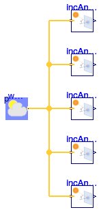
This example computes the solar incidence angle on tilted surfaces. There are fives surfaces, a horizontal surface and a surface that faces Norths, East, South and West.

Extends from Modelica.Icons.Example (Icon for runnable examples).

Modelica definition

model IncidenceAngle "Test model for solar incidence angle" extends Modelica.Icons.Example; Buildings.BoundaryConditions.SolarGeometry.IncidenceAngle incAngHor( til=Buildings.Types.Tilt.Ceiling, lat=0.73097781993588, azi=0.3) "Incidence angle on horizontal surface"; Buildings.BoundaryConditions.WeatherData.ReaderTMY3 weaDat( filNam=Modelica.Utilities.Files.loadResource("modelica://Buildings/Resources/weatherdata/USA_IL_Chicago-OHare.Intl.AP.725300_TMY3.mos")) "Weather data (Chicago)"; Buildings.BoundaryConditions.SolarGeometry.IncidenceAngle incAngNor( lat=0.73097781993588, azi=Buildings.Types.Azimuth.N, til=Buildings.Types.Tilt.Wall) "Incidence angle on North-facing surface"; Buildings.BoundaryConditions.SolarGeometry.IncidenceAngle incAngWes( lat=0.73097781993588, azi=Buildings.Types.Azimuth.W, til=Buildings.Types.Tilt.Wall) "Incidence angle on West-facing surface"; Buildings.BoundaryConditions.SolarGeometry.IncidenceAngle incAngSou( lat=0.73097781993588, azi=Buildings.Types.Azimuth.S, til=Buildings.Types.Tilt.Wall) "Incidence angle on South-facing surface"; Buildings.BoundaryConditions.SolarGeometry.IncidenceAngle incAngEas( lat=0.73097781993588, azi=Buildings.Types.Azimuth.E, til=Buildings.Types.Tilt.Wall) "Incidence angle on East-facing surface"; equation connect(weaDat.weaBus, incAngHor.weaBus); connect(incAngNor.weaBus, weaDat.weaBus); connect(incAngWes.weaBus, weaDat.weaBus); connect(incAngSou.weaBus, weaDat.weaBus); connect(incAngEas.weaBus, weaDat.weaBus); end IncidenceAngle;

Buildings.BoundaryConditions.SolarGeometry.Examples.ProjectedShadowLength Buildings.BoundaryConditions.SolarGeometry.Examples.ProjectedShadowLength

Test model for projected shadow length

Buildings.BoundaryConditions.SolarGeometry.Examples.ProjectedShadowLength

Information

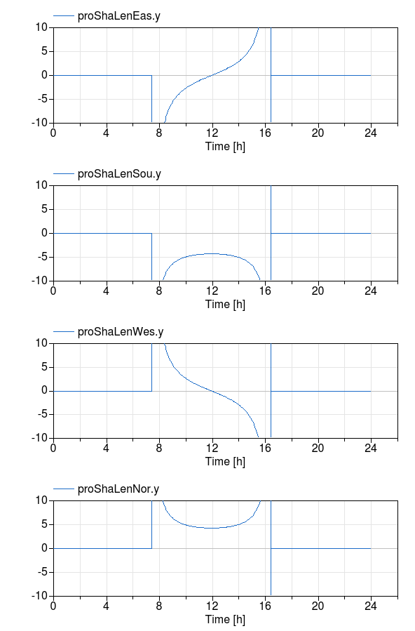
This example computes how far a shadow of a 2 meter high object is in different directions. The figure below shows this length for January 1 in Chicago. Note that the length of the shadow is negative if the azimuth is selected to be south because the shadow is towards the north.

Simulation results

Extends from Modelica.Icons.Example (Icon for runnable examples).

Parameters

TypeNameDefaultDescription
Lengthh2Height of object [m]

Modelica definition

model ProjectedShadowLength "Test model for projected shadow length" extends Modelica.Icons.Example; parameter Modelica.SIunits.Length h = 2 "Height of object"; Buildings.BoundaryConditions.SolarGeometry.ProjectedShadowLength proShaLenEas( azi=Buildings.Types.Azimuth.E, h=h, filNam=Modelica.Utilities.Files.loadResource("modelica://Buildings/Resources/weatherdata/USA_IL_Chicago-OHare.Intl.AP.725300_TMY3.mos")) "Projected shadow length facing east"; Buildings.BoundaryConditions.SolarGeometry.ProjectedShadowLength proShaLenSou( azi=Buildings.Types.Azimuth.S, h=h, filNam=Modelica.Utilities.Files.loadResource("modelica://Buildings/Resources/weatherdata/USA_IL_Chicago-OHare.Intl.AP.725300_TMY3.mos")) "Projected shadow length facing south"; Buildings.BoundaryConditions.SolarGeometry.ProjectedShadowLength proShaLenWes( azi=Buildings.Types.Azimuth.W, h=h, filNam=Modelica.Utilities.Files.loadResource("modelica://Buildings/Resources/weatherdata/USA_IL_Chicago-OHare.Intl.AP.725300_TMY3.mos")) "Projected shadow length facing West"; Buildings.BoundaryConditions.SolarGeometry.ProjectedShadowLength proShaLenNor( azi=Buildings.Types.Azimuth.N, h=h, filNam=Modelica.Utilities.Files.loadResource("modelica://Buildings/Resources/weatherdata/USA_IL_Chicago-OHare.Intl.AP.725300_TMY3.mos")) "Projected shadow length facing North"; end ProjectedShadowLength;

Buildings.BoundaryConditions.SolarGeometry.Examples.ZenithAngle Buildings.BoundaryConditions.SolarGeometry.Examples.ZenithAngle

Test model for zenith angle

Buildings.BoundaryConditions.SolarGeometry.Examples.ZenithAngle

Information

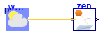
This example computes the zenith angle, which is the angle between the earth surface normal and the sun beam.

Extends from Modelica.Icons.Example (Icon for runnable examples).

Modelica definition

model ZenithAngle "Test model for zenith angle" extends Modelica.Icons.Example; Buildings.BoundaryConditions.SolarGeometry.ZenithAngle zen(lat=0.2) "Zenith angle"; Buildings.BoundaryConditions.WeatherData.ReaderTMY3 weaDat( filNam=Modelica.Utilities.Files.loadResource("modelica://Buildings/Resources/weatherdata/USA_IL_Chicago-OHare.Intl.AP.725300_TMY3.mos")); equation connect(weaDat.weaBus, zen.weaBus); end ZenithAngle;